![]() Library
Specification
Library
Specification
DSpatial is still on the drawing boards. To ease the task of developers, ourselves and the users of DSpatial, we are here defining the basic architecture of DSpatial. This basic architecture should enable developers to add functionality in a consistent manner. The main parts of the library, data format support, analysis, and visualization, will all be specified as abstract interfaces, which new code implements to support specific functionality.
You are invited to participate in this specification. We would like to hear from Delphi and Kylix developers, as well as from others interested in geospatial analysis. You can use the links in this document to access the forums on our SourceForge site, from where the develops collect the comments. For bug reports or feature requests, use the appropriate links.
At this time some things are
not yet cast in stone, so take this opportunity to make your opinion heard.
Wherever you find a ![]() an item is still being discussed, while a
an item is still being discussed, while a ![]() indicates that an item has been conclusively specified. These latter items
have their complete text on this site, as well as in document form on
our SourceForge Docs
repository.
indicates that an item has been conclusively specified. These latter items
have their complete text on this site, as well as in document form on
our SourceForge Docs
repository.
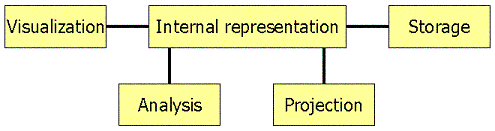
DSpatial revolves around the manipulation of data representing some phenomenon on the Earth's surface. That data has to be stored to and retrieved from a persistent medium (e.g. harddisk, CD-ROM, internet), manipulated, and visualized. The following clickable diagram should then be quite self-explanatory: